The Project
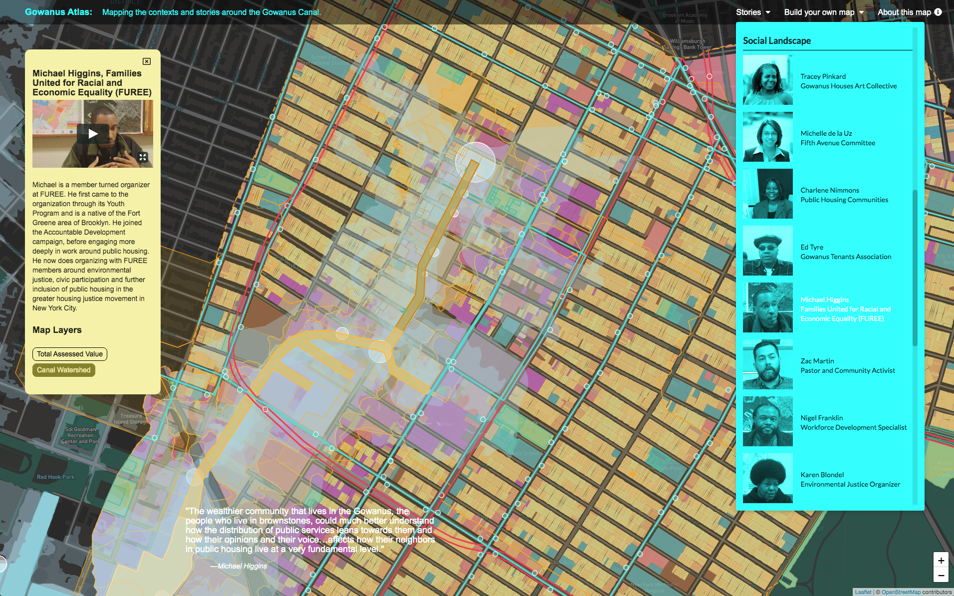
Gowanus Atlas is a dynamic, web-based interface that tells the story of the community around the Gowanus Canal, a neighborhood defined by its people, history, and diversity. It will give residents, business owners, organizations, activists, developers, and agencies access to quantitative and qualitative data about the area's rapidly changing conditions, its challenges, and the community's future. It is an active, living communal resource for connection, participation, and activism.
Initially, Gowanus Atlas will collect public data sets within the watershed, such as infrastructure, land use, flood zones, demographics, Superfund cleanup, etc., that tell the story of how the area developed and its current conditions. As it expands, we will conduct community outreach and add new data sets, such as sensory conditions, air quality, environmental contamination, displacement of affordable retail and youth resources, and access to healthy regional food options. Together with the public data sets, Gowanus Atlas will synthesize the area’s characteristics and visually explain in graphically-rich downloadable maps how complex urban, ecological, and sociological conditions define the neighborhood. Users can toggle the data sets on and off to curate and create their own maps.
As Gowanus Atlas develops over the next few years, it will use state-of-the-art data analytics to visualize the impact of changing conditions over increasing time spans: one year, ten years, fifty years. Not only will Gowanus Atlas provide a platform for understanding the complexities of a changing urban ecosystem, it will offer archival and historical value to the greater community who will be living with this urban regeneration for many years.
Why We're Doing It
The timing of our Gowanus Atlas project is critical: the Gowanus neighborhood is undergoing rapid changes and will be a very different place once the Superfund cleanup is complete and the area rezoned. The surrounding communities will be heavily impacted by the influx of new residents, businesses, artists, traffic, construction, etc. Each community is grappling to understand how they will be affected - Gowanus Atlas will facilitate a broader understanding of these impacts, their challenges, and the opportunities.
Gowanus Atlas is an outgrowth of our third competition, Axis Civitas. Cities, and the sub-cities within them, are human constructed ecosystems that are defined as much by their inflows and outflows as by their political boundaries. It is expected that 70% of the world's population will live in urban centers by 2050; this migration is creating pressure to expand city areas that are scarred by 19th and 20th century industry, have insufficient infrastructure, or are at risk with the rapid environmental changes wrought by global warming. To better manage the impact of this rapid population shift and create sustainable cities, urban communities need tools that allow citizens and planners to project the collective social, economic, community, and environmental impact of development as an integral part of the political decision-making process.
Featured